Thursday, August 29, 2019

Where'd You Go, Waterfall?

This week I thought I'd take a look at Moyie Falls, just east of Bonners Ferry and the area checked out the week before. I've seen this falls from afar, most recently in 2007 when my brother and his wife visited and I gave them the grand tour of where our dad took me and mom while we searched out places to fish (see this post). Actually, now that I look at the photo on that post which I've added above, I guess we couldn't actually see the falls, but just the dam above them holding back some water (center right). Maybe I'm just remembering other people's photos. At any rate, I know I've never been to the spot where you can see them close up. So after doing my usual research to obtain decent directions and scoping out what else I might look at nearby, off I went.


I should have heeded more closely what others were saying online about this falls. That spring was the best time to view it (of course - ALL falls are more spectacular with spring runoff swelling the rivers), that the dam controlled how much water went over the falls (of course - true of any dam but surely there will be SOMETHING running over them). But no. I had arrived in the middle of the week, near the end of summer, and this sign near the parking area tells the story. Well, I've driven the 40 or so miles here, so I'm going to go take a look anyway.


Backing up a bit, the Moyie River starts its life in Canada. In fact, Copper Creek empties into it not far below Its falls which was my first chasing waterfalls road trip. And here at the falls it is near the end of its life as it will shortly empty into the Kootenai River. On Wikipedia, the falls are describe as "an 85 foot (26 m) waterfall on the Moyie River. Crashing through a rocky canyon, the Moyie River descends in tiered form. While the upper portion plummets 60 to 100 feet under an obsolete bridge connecting the gorge, the lower portion tumbles 20 to 40 feet." (The obsolete bridge has since been removed.) Now doesn't that sound worth seeking out? So I wound my way through the little town of Moyie Springs and down a steep road to the parking area.


That bridge over the gorge is really something, especially when you are passing right under it, hearing the cars and trucks overhead.


And viewing it from below. It's the 2nd highest bridge in Idaho.


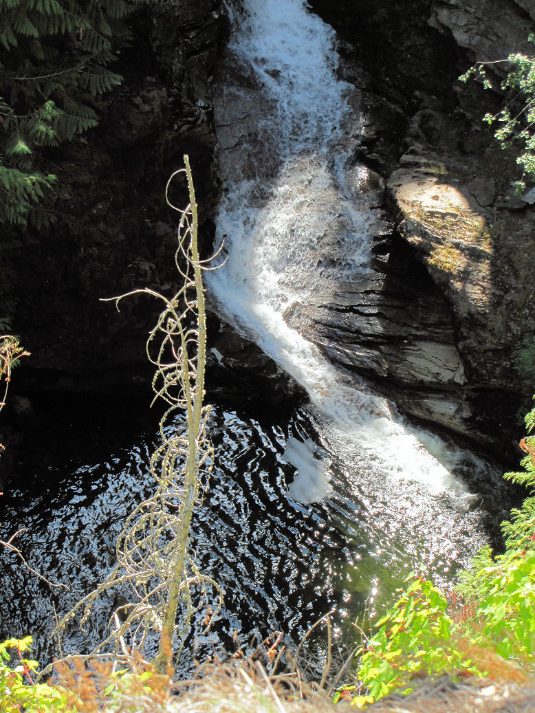
But it's the falls I'm after, so I park and start the trudge back up the road to a couple of viewing spots. And right away, as I peek over the edge of the road, I can see how very far down the river is and what a steep drop-off it is. And there's water, so maybe some waterfall to see.


 Nope. This is supposed to be the upper falls. As near as I can tell, that rockface is where the water must come down to create the falls. In fact if you click on this picture and zoom in on that spot above the branches in the middle, you should be able to see a pool of water.


Here, I've done it for you, see even better if you click on it.


And on the adjacent rock face, the ubiquitous mosses and lichens.


Hope springs eternal for determined people like me, so I continue my trudge up the road to get a look at the lower falls. There's a pool of water, and the creek running off in the distance but...


Yeah, nothing happening there either. But I can envision that water plummeting down at an angle across this rockface to the pool below. If you click on the picture and zoom in to the spot just up and left of center, you can see an area that looks a bit like riverbed before the plunge.


One more look down the gorge and at the massive bridge before heading back to the car.


As long as I was there, I did drive on up the road a bit, to take a look at this dam (no water going over it either) and a small day use area along the bit of backed up river. But basically, not much else to see. I'd be lying if I said I wasn't disappointed.


That being said, I still had a couple of roads I wanted to drive up. I'd stopped off at the information center in Bonners Ferry to get some better maps and ended up having a very informative chat with the lady there who had personal experience on the roads in question and stuffed a bunch of hiking pamphlets in my hand. I put in about 125 miles in all on this day, about 80 driving up and back, and the rest poking around for several hours up a couple of roads of various improvement. I was surprised at how many houses were up these roads on either side of the Moyie River (but seldom in sight of it) and that there was even some farming and ranching going on. Couldn't resist capturing this dilapidated barn which surely can't withstand many more winters. This particular road eventually wound up quite high, leaving me doing my usual gawking at the mountains still far above me and the view down through narrow valleys. It reminded me of how my dad loved to go on the old logging and forest service roads, me nose pressed up against the passenger-side window taking in the variety of trees and tremendous views.


The other road I explored was paved for quite a long way, passed close by a small lake (no sign, no turnout and frankly, unimpressive compared to my Pend Oreille Lake), more houses and farmlands and even a development called Meadow Creek Estates, and eventually crossed the Moyie River several times. I was going to go as far as a camp ground near where the road crossed the river but I totally missed the sign. The road also followed and crossed over train tracks numerous times, and since I'd had so little to take pictures of, I stopped to take one of this train bridge which is probably quite old and that I was quite taken with for some reason. This road also continues north nearly to the turnoff to Copper Falls, and I certainly didn't want to end up back there this late in the day, so even though I hadn't found that campground, I soon turned around and back towards the highway. At which point I spotted the sign at the first crossing of the river. Of course. I'd been that kind of day. I did drive down into the campground - big and shady and really nice, the sort of one my dad would have given a thumbs up to had we come upon it on a fishing trip - and wouldn't you know it, there were signs for two hiking trails which seemed to start from the day use area, one to an overlook and one along the river. Well, way to late to be hiking now; have filed all this information away for a return trip at a better time of year.

So this week's road trip felt like a bust, a failed search for waterfalls, no real hiking, a lot of driving just to look at a lot of trees, a lot of rocks, and a little water. I'll do better next week. I'm being guaranteed that the river in question and its falls will be flowing with a "surprising amount of water".  

Tuesday, August 27, 2019

Kootenai National Wildlife Refuge

It was getting late in the afternoon by the time I came off the Myrtle Falls Trail, time for a quick lunch. The falls trail is on the Kootenai National Wildlife Refuge, the trailhead across the road from the refuge information center which has restrooms, pamphlets and even telescopes for looking out over the refuge and spotting said wildlife.


There's a separate large barn and lots of educational activities that go on here. On the edge of the parking lot is this recreation of an eagle's nest.


The refuge is primarily wetlands between the Selkirk mountains and the Kootenai River. Check out this link to see an illustration of the ponds within the refuge. It also shows adjacent trails and an overlook I visited before heading home.


There's also an auto tour road but wouldn't you know it, the road closed for extensive maintenance the very day I was there.


I'd spotted a bench along this path (just out of view to the left) where I decided to sit a spell, enjoy the view and eat my lunch.


Here I thought my hiking was done for the day, but instead, I spotted this sign as I headed to the bench. One last easy trail to enjoy!


I was glad I made time for it. Usually when I get in gear for hiking, it's late in the summer and everything is dried up, flowers past their peek if any at all. Along this trail I found a few worth getting a picture of.


It was quite breezy and I was having difficulty getting a shot of these while they waved in the wind. Just as I was about to click in a pause, this fat bee flew into my shot, its weight holding the flowers in place!


The trail winds around a pond created by beavers, with signage along the way. If you click on the photo you should be able to make out what this sign says about sap suckers and birches.


At one point the trail passes over a bridge where water from the pond escapes. Can you guess what is causing those dark dots that look like paw prints?


Water bugs! I don't know their official name but I remember seeing these often as I fished streams with my dad. First time I've been able to get a good shot of one, resting on the water and creating those bubbles.


Around I went on the loop until I got to a spot to get a good shot of the pond, just after a small fish had jumped out of it. Such a welcome cool spot on a hot afternoon.


And then, peering through branches and tall grass, I spotted a turtle that had crawled up on a log. I've seen so many pictures others have taken of turtles on logs in the area, but I'd not seen one until this day. It was pretty hard to get a shot through waving grass and my own unsteady hand. A tripod would have been helpful.


Nearly time to head home, but I decided first to check out the overlook up the road a bit. The refuge has several of these photography blinds set up, and wouldn't you know, just as I was walking up to it, a heron flew up near it and away. Oh sure, I thought. I wasn't betting on seeing anything anyway, but now that I know you are here, you just fly away before I can get a good look at you?


The view from the blind was lovely, with or without birds, but I could see some far off, probably ducks, and where I thought that heron had set down, in the green area beyond the dark clump on the middle right.


I cranked up my zoom to maximum and started shooting away blindly, hoping to catch something, really wishing I had a tripod now. A pair of binoculars would have been nice too. Note to self, pack both next time. Because look! When I looked at this photo on the computer screen at full size, I spotted two turtles on a rock there on the right. Still don't know what kind of waterfowl I caught in this shot.


I eventually spotted my heron though on the camera's screen. Some sort of falcon or hawk is flying in from the left, heron off to the right, click on the picture for a larger view and see if you can spot anything else.


Even though I couldn't see very clearly, I could see the way that heron strode out of the heavy grasses and into an area where he could spot fish. I did see him snatch one up but couldn't get a picture of it. Dinner taken care of, he strode back into the grasses, mostly out of sight.


This was surely an unexpected and very nice way to wrap up my road trip. And as I returned to the car, this view. I can't get enough of these mountains. 

Saturday, August 24, 2019

This Week's Waterfall

Wednesday I headed north again in search of my next waterfall on Myrtle Creek. About half as far away as Copper Falls - about 40 minutes to the trailhead adjacent to Kootenai  Wildlife Refuge which has also been on my list of places to visit, so able to kill two birds with one stone as it were.


It was also about 10 degrees hotter than the day I went to Copper Falls - mid 80's and a bit muggy - but I knew that wouldn't be an issue once I headed into the forest which is always comfortably cool. But wait. This trail is paved??? And I'm not supposed to be taking extended walks on pavement. Hmmm - well, I'm not backing out now!


Another surprise - this is a storybook trail, like the one at my little park close to my house. No signage about the area you are walking through, but the storybook makes it kid friendly I guess.


Winding path rising gently, big trees abound.


Trees that at some point in their growth became one at the base. Siamese twins, joined at the hip, I couldn't help myself!


Soon I reached a metal bridge crossing Myrtle Creek.


Water downstream from the falls, more than at Copper Creek.


And flowing under the bridge and onward. A real mountain creek, memories of childhood.


On the hillside above the creek I spotted a brush with brilliant red berries.


I was thinking thimbleberries but this closeup shows a cluster of berries different from thimbleberries I know.


The paved trail ended at the bridge. The trail beyond narrowed and was dirt - just what the doctor ordered. In several places springs trickled from the hillside and across the trail, contained by boards to keep them from getting out of hand, a rock strategically placed to aid in stepping over.


I spotted another tree duo, this one separated at the base but eventually leaning on each other and joining farther up.


And right next to the trail was this thick tree that had been charred by fire all around and quite a ways up.


And yet it still lived, surviving whatever fire passed through and continuing to grow. Nature is amazing.


Every now and then I could glimpse the valley floor and mountain range in the distance as the trail climbed steeply and switchbacked its way to the falls overlook.


The trail to the top is supposedly only a quarter mile long but it felt longer, no doubt because of the steepness of the trail. So heavily wooded that even at the overlook, this was all you could see of the valley and mountains across the way.


But no matter, look the other direction and here are the falls! Unlike Copper Falls, these falls do not cascade over a cliff but have cut through a gorge to fall about 100 feet. One source I found said that from the overlook you are looking down 200 feet. The elevation here is a little over 2000 feet compared to the 3400 feet of Copper Falls. I've kept the jpgs that pop up when you click on the picture large so you can explore all the details of the falling water and rock faces if you so desire.


Yes, if you are looking closely at the large versions, there is some sort of cable hanging down into the water. Not visible to the naked eye and I have no idea what that is about.


The photo has flattened this out, but it looked to me like a big round boulder resting against the rock face and covered with moss.


One source I found states: "This great cascade has exposed the native brown quartzites forming a beautifully color filled sprite." As lovely a description as one could want - can't top that!


Someone has given some care to this overlook area, adding this wrought iron backrest to the big rock so one can comfortably rest.


And placing etched pavers and stone steps with animal paw prints to help you move from one observation area to the other.


And of course, you MUST see and hear this waterfall in action! 

I'll share the wildlife refuge part of this trip in the next post.